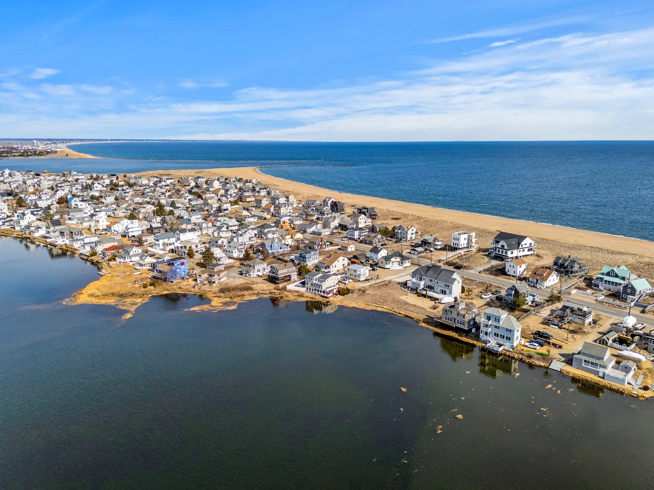
Wondering which part of Plum Island fits your style? This barrier island represents three different towns and the vibe changes block by block — ocean surf on one side, calm marsh on the other, and a federally protected refuge covering two-thirds of the island. If you’re weighing a second home or planning a move, it helps to know how each micro‑neighborhood lives through all four seasons. Below, you’ll find a clear, local guide to the beaches, views, and daily rhythms across the island, plus practical tips on access, flood risk, and rules. Let’s dive in.
Plum Island at a glance
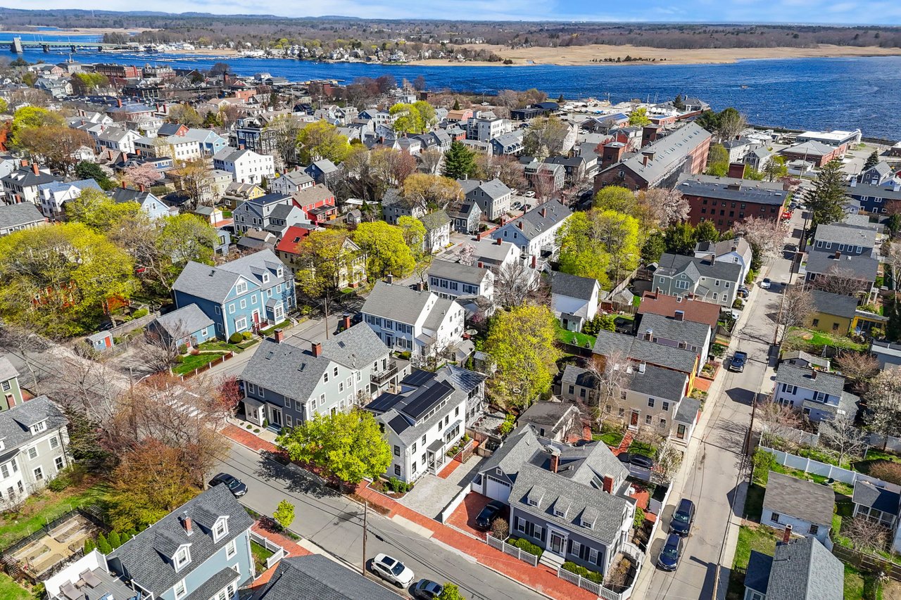
Plum Island runs north to south with the Atlantic Ocean on the east and the Merrimack River–Plum Island Basin and salt marshes on the west. Much of the island is undeveloped and part of the Parker River National Wildlife Refuge, a large protected area with trails, dunes, and seasonal restrictions managed by the U.S. Fish & Wildlife Service. You can review current rules and maps on the Parker River National Wildlife Refuge site.
A single causeway from Newburyport connects the island to the mainland. Daily life shifts with the seasons. Summers bring beach traffic, visitors, and full parking lots. Fall through winter is quieter and more exposed to coastal weather.
Oceanfront: beaches, surf, sunrise
If you want the classic beach house experience, the oceanfront delivers. Homes face the Atlantic with wide sandy beaches and the steady sound of surf. Sunrises and direct beach access are the headline features, and summer days center on swimming, sunbathing, and long walks on the sand.
- What you’ll feel: Constant salt air, more wind, and the rhythm of waves.
- Daily flow: High summer energy with lifeguard hours and seasonal beach rules. Check the City of Newburyport’s official site for current beach and parking information.
- Practical notes: Storm surge, salt spray, and coastal erosion shape building style and upkeep. Expect elevated foundations, coastal‑resilient materials, and more frequent exterior maintenance.
Best fit: You prioritize ocean views and beach access and you’re ready for the realities of coastal maintenance and seasonal crowds.
Insider tip: Look for waterfront homes on Reservation Terrace, Northern Boulevard, Southern Boulevard, Annapolis Way and Fordham Way plus odd numbers street names such as 73rd, 49th, etc for waterfront locations and ocean views. Even numbers street names are on the ocean side of the island but typically have basin-side views. But, all homes on numbered side street names are beach accessible.
Basin and back‑bay: marsh, sunset, calmer water
The west side looks over Plum Island Basin, tidal creeks, and broad marsh vistas. It is generally quieter and less windy than the ocean side, with sunsets that can be spectacular.
- What you’ll feel: Calmer water, bird life over the marsh, and a stronger neighborhood feel along clustered streets and canals.
- Daily flow: Kayaking, paddleboarding, and fishing are common. You’ll hear less surf and more shorebirds.
- Practical notes: Flooding and tidal inundation remain considerations. When you tour, request elevation details for each property.
Best fit: You want water access and views without constant surf exposure, plus a more residential rhythm.
Insider tip: Old Point Road is the key access road to all streets on the basin side of Plum Island.
Near the Wildlife Refuge
The closer you get to the Parker River National Wildlife Refuge, the more nature takes center stage. You’ll find quiet mornings, large stretches of dunes, and prime birding.
- What you’ll feel: Low ambient noise and light, especially at night. Nature drives the schedule here.
- Daily flow: Early walks, wildlife viewing, and seasonal closures that protect nesting birds. For refuge regulations and closures, start with the Parker River National Wildlife Refuge.
- Practical notes: Conservation rules guide where you can walk and park. Plan ahead for access.
Best fit: You value solitude, wildlife access, and a conservation‑minded setting.
Insider tip: Look for homes on Sunset Drive, Fordham Way, Harvard Way, Jackson Way.
Getting around: access and commuting
Plum Island sits minutes from downtown Newburyport. The MBTA Newburyport Line connects Newburyport station to Boston’s North Station; check MBTA schedules for current travel times and frequency. Driving miles to Boston are often cited in the 35 to 45 mile range. In peak summer, expect delays onto and off the island. If you are evaluating a home, visit on a weekend in July and again on a weekday in October to feel the difference.
- Check MBTA schedules on the Newburyport Line.
- Review seasonal beach and parking rules on the City of Newburyport’s official site.
- For coastal weather context, look at National Weather Service Boston/Norton updates.
Parking on Plum Island:
Be sure to note restrictions and regulations if planning a day trip to Plum Island. There are two towns on Plum Island, each with different parking permits and restrictions. Sandy Point State Reservation and Parker River National Wildlife Refuge each also have parking rules. Most parking in lots and on the street on Plum Island requires a permit or parking pass.
Sandy Point State Reservation is extremely limited with approximately 40 spots. Access is through the Parker River National Wildlife Refuge and fills up early in the summer with one in/one out after the lots are full. https://www.mass.gov/locations/sandy-point-state-reservation
Plum Island Point Beach & Parking Lot is located on the northern end of the island. This lot is run by the Harbormaster Department with resident and non-resident daily rates. Located at 278 Northern Blvd, Newburyport, MA 01950. More information can be found at https://www.cityofnewburyport.com/harbormaster/pages/plum-island-point-beach-parking-lot
Parker River National Wildlife Refuge is by permit only but fees are reasonable. Day passes are available as are annual passes. See full details at https://www.fws.gov/refuge/parker-river
If you're looking to park at Plum Island Center, you're best bet is private parking lots. Parking at Plum Island Center and along Northern Blvd on the east/beach side of the street is permit only for Newbury residents with Newbury Resident parking permits. More details at https://newburyma.gov/DocumentCenter/View/2324/Newbury-Parking-Permits-Faq-2018-PDF?bidId=
Flood risk, resiliency, and insurance
Coastal flood risk is a material factor for oceanfront and many basin‑side properties. Build this diligence into your search from day one.
- Review the property’s flood zone on the FEMA Flood Map Service Center.
- Request an elevation certificate if available.
- Get property‑specific quotes for flood insurance and ask about National Flood Insurance Program requirements.
- Ask about local dune management, beach nourishment, and any municipal mitigation projects.
- Confirm zoning and permitting with Newburyport’s Building and Zoning departments before planning renovations.
Pro tip: Compare two similar homes on the same street. A small elevation difference can lead to very different insurance costs and maintenance plans.
Seasonal life, rules, and wildlife
Summer brings day visitors, events, and heavy parking demand around public access points. Late fall through winter, most streets quiet down and you’ll feel the full power of coastal weather. Portions of the island and adjacent beaches fall under federal and municipal rules that shift with the season.
- Municipal beaches: Lifeguard hours, dog policies, and parking fees are seasonal. See the City of Newburyport’s official site for current rules.
- Parker River National Wildlife Refuge: Certain areas close seasonally to protect nesting shorebirds. Regulations are posted by the U.S. Fish & Wildlife Service on the Parker River National Wildlife Refuge site.
Spend time on the island in both high season and the off‑season to confirm the daily rhythm that fits you.
Find your fit: quick matches
Use this quick guide to align your goals with the right side of the island.
- Oceanfront: For sunrise views, steps to the sand, and an energetic summer scene. Plan for coastal maintenance and seasonal crowds.
- Basin/back‑bay: For marsh and sunset views, calmer waters, and a quieter residential feel. Verify elevation and tidal exposure.
- Near the Refuge: For direct access to trails and wildlife in a low‑noise setting. Expect more conservation rules and seasonal closures.
Plan your next steps
If Plum Island is on your shortlist, map your process before you tour.
- Visit in different seasons and at different times of day.
- Pull flood maps and elevation details early.
- Talk with insurers about realistic premiums and coverage.
- Confirm utilities, internet options, and any association rules for the specific property.
- If you are considering rental income, verify current Newbury and Newburyport rules and any registration requirements.
When you are ready for tailored guidance on property fit, pricing, and coastal ownership logistics, connect with a local advisor who lives and works these streets every day. To start a conversation or request a pricing read on your current home, reach out to Kevin Fruh.
FAQs
How close is Plum Island to downtown Newburyport?
- It is a short drive across the causeway, but actual time varies by season, day of week, and your location on the island.
Is there public transit from Plum Island to Boston?
- There is no rail on the island; you can use the MBTA Newburyport station and ride the Newburyport Line to North Station.
Do Plum Island homes typically need flood insurance?
- Many oceanfront and basin‑side properties do; check the FEMA Flood Map Service Center and get quotes specific to the property.
What rules apply in the Parker River National Wildlife Refuge?
- The refuge has seasonal closures and activity rules to protect wildlife; see the Parker River National Wildlife Refuge for current guidance.
How can I track coastal weather for Plum Island home visits?
- For reliable forecasts and storm updates, use the National Weather Service Boston/Norton office page.